

 To really understand the Oneida County‘s 1770 Coxe Patent, we should start with Heath Patent, granted some 140 years earlier by King Charles I. The 1629 document gave Sir Robert Heath (1575-1649) the patent for the Province of Carolana (Carolina) “to enlarge the Christian religion as our empire and increasing the Trade and Commerce of our Kingdom.”
Heath, a protege of George Villiers, 1st Duke of Buckingham, served as the Crown’s Attorney General from 1625 and served on a Virginia tobacco trade commission in 1627-8.
He essentially founded North and South Carolina, although they weren’t split until the early 17oos, and he never established settlements there. His grant covered all lands between 31 degrees and 36 degrees north latitude extending from the Atlantic to the Pacific, including all or parts of present-day Louisana, Alabama, Florida, Georgia, Mississippi, Tennessee and the Carolinas.
Heath held all this as the sole proprietor with broad feudal powers to collect taxes, raise an army to protect the colony, and “confer favours, graces, and honours upon deserving citizens.”
Heath had hoped to settle Huguenot refugees in England there, but Charles excluded settlement by foreigners and allowed only members of the Church of England, so Heath assigned his grant to George Berkeley, 1st Earl of Berkeley.
 When King Charles I was executed in 1649 Heath fled to France where he died, but after the Restoration in 1660 his heirs tried to regain their claim to Carolana.
Charles II ruled the claim invalid and instead gave the rights to the patent to eight Lords Proprietors in 1665. At that time promotional attempts to entice settlers stressed the flora, fauna, climate, rich soil, and the abundance of crops.
The English civil wars (1639 to 1653) had encouraged some refugees to move to the Virginia Colony, and eventually Virginians began to settle the Carolinas permanently. By 1720 half of the population were enslaved.
Claimants continued to contest the land, but in 1768 the Heath title was finally extinguished with a compensatory grant of 100,000 acres in the Royal Province of New York to the descendants of Daniel Coxe (he had acquired the Heath claim in the 1690s from Sir James Shaen, or his son Arthur).
The Daniel Coxe family was a major property owner in New Jersey between 1687 and 1692. Daniel Coxe was West Jersey’s largest landowner with an estimated 577,000 acres.
The compensatory grant was conditioned on “said descendants execut[ing] a grant, release, and surrender to the crown of all their right and title or pretended right and title to the Province of Carolana and Islands as described in a certain patent to Sir Robert Heath.”
The Cox Patent in Oneida & Tioga Counties
In 1770 King George III finally authorized the Coxe Patent to William Coxe, Daniel Coxe, Rebecca Coxe, and John Tabor Kempe (then attorney general of the Colony of New York and the only New York resident listed in the grant) and his wife Grace Coxe (all descendants of Daniel Coxe, who had never seen the land).
The Patent included 47,000 acres along the 1768 Treaty of Stanwix line in today’s Oneida County. It also included a grant of about 30,000 acres in today’s Tioga County and 23,000 elsewhere, though exactly where is still much the subject of debate.
In Oneida County, the patent covered parts of today’s City of Rome, and towns of Westmoreland, Kirkland, Whitestown, New Hartford, Paris, and Bridgewater. The line extended 26 miles in Oneida County. I was signed by Cadwallader Colden, “at our fort, in the City of New York,” on May 20, 1770. Colden was serving as acting colonial governor at the time.
 The Coxe Patent was bounded on the south by Bridgewater, on the east by Cosby Manor, Bayard’s, Morris’ and the Oriskany Patent. To the west were Indigenous lands, primarily those of the Iroquois, Delaware and Shawnee.
The west line of the Coxe Patent was the same as the west line described as the “Property Line” in the 1768 Fort Stawwix Treaty. The grant stated that “mines of gold and silver,” also all white pine or other sorts of trees, 24″ in diameter 12″ from the ground, fit masts for the Royal Navy, were reserved for the crown. It was granted without quit rents for ten years.
The Coxe Grant required the formation of two townships: Carolana southeast of the Oriskany Creek, and Coxeborough northeast of the Creek. The patent designated that each township have two assessors, one treasurer, two overseers of highways, two overseers of the poor, one collector, and four constables.
Although maps show both new towns, they never became municipalities. The Coxe Patent had seven grand divisions: 1-5 in Carolana; and 6 and 7 in Coxeborough.
George Washington and George Clinton owned large sections of grand divisions 1 through 6, as did Marinus Willett, a regimental commander at Fort Stanwix during the Revolution.
Willett bought over 700 acres in August 1784 near the village of Westmoreland. Later he owned the 2,000-acre Willett’s Patent in the Town of Steuben and was also partner with Elias Van Benscoten of a smaller patent in the Town of Ava known as “Willett’s Small Patent.”
In his will, George Washington listed 2,000 acres on the Mohawk River which remained unsold from the original 6,071 acres granted to Daniel Coxe and bought by Marinus Willett and wife. The latest sales had been six dollars an acre and what remained unsold would fetch that or more.
Rev. Samuel Kirkland received a grant from the Oneidas and New York State just west of the 1768 Stanwix Treaty line. Eventually the grant owners sold off their lands, cleared trees, started farms, and built new settlements.
Moses Foote arrived in Clinton, NY, in March 1787 with six other families, but did not know that this land was already part of Coxe’s Patent. Foote had to travel to Philadelphia in the summer of 1788 and purchase the land for ten schillings per acre from the Coxe family.
Foote bought 2,016 acres of part of the 6th Division from William and Mary Coxe and set out 20 lots of about 100 acres each, on which early white settlers such as Aaron Kellogg, Ludim Blodgett, Rufus Blodgett Judah Stebbins, John Bullen Levi Sherman, and Samuel Hubbert established themselves.
 Three other land grants border the Coxe Patent:
1 – The one-mile square Wemple Patent was given to Abraham Wemple in 1789 and is mostly in the Town of Westmoreland. It includes parts of the Town of Kirkland in the northwest section (parts of Griffin, Campus, Bryden, College Hill, and Skyline Roads).
Wemple was a colonel of the Schenectady Regiment and had served at various Mohawk Valley forts throughout the Revolution. He owned a farm in Guilderland, Albany County (he was buried in 1799 near Route 20).
2- The Kirkland Patent was granted in 1788 to George W. and John T. Kirkland, twin sons of Samuel Kirkland, and to Rev. Kirkland himself. It totaled 4,750 acres extending from the 1768 Stanwix Treaty line near Harding Road to Skyline Drive and was approximately two miles wide and three-and-a-half miles long, oriented north to south.
3 – The Brothertown (or Brotherton) Patent was originally granted by the Oneida to the remnants of Indigenous tribes of Connecticut and Long Island, whose land had been encroached on by white settlers. The grant occurred in 1784 and was confirmed by the New York State Legislature in 1789.
It consisted of some 30,000 acres (later reduced) in the southern part of Kirkland and the Town of Marshall. It extended west along from near the Dwight Avenue and Route 12-B intersection west of Post Street, and then south to today’s Oriskany Falls and Waterville. The “Brothertown Indians” leased or sold much of this land to settlers, most went to Wisconsin in the early 1830s, as did many Oneida and Stockbridge people.
This land in what is now Tioga County originally was contained in the Plymouth Grant of 1606 by King James I for lands between the 40 and 48 degrees latitude. It included today’s towns of Nichols and Owego (formerly called town of Hambden).
Its northern border was the Susquehanna River and was described as a “body of land lying between the Owego Creek [River] and the Chenango River.”
After The Revolution
At the time of the American Revolution, when a person was declared guilty of a high crime, due process was circumvented and they were said to be “attainted” without the opportunity to defend himself at trial, and their property is seized. Attainder was considered so extreme that it was specifically prohibited by the later United States Constitution.
As a loyalist, John Tabor Kempe’s land was attainted by the New York Legislature by the 1779 Act of Forfeiture (also known as the Confiscation Act). The Governor was authorized to appoint Commissioners of Forfeiture to dispose of confiscated estates with tenant farmers who had leased and improved the land and who were given first priority to purchase the tracts.
The state sold Kempe’s parts of the Coxe Patent. Kempe was allowed to keep on his home in the city of New York. He returned to England and died August 1792.
 In addition to John Tabor Kempe, fifty-eight other (mostly prominent) Loyalists were attainted. Among them were Sir John and Guy Johnson, Daniel Claus, and John and Walter Butler. The state gained $3.6 million from the sale of confiscated property.
Connection in the right places could keep one from being attainted. For example, Tench Coxe was a successful merchant, aristocrat, a longtime member of the Philadelphia society, but a loyalist. However, he had a cousin, Tench Tilghman, who was a respected aid-de-camp to George Washington.
In May 1778 the Supreme Executive Council of Pennsylvania attainted Tench Coxe for High Treason. He quickly made an oath before Chief Justice Thomas McKean, a Coxe family friend, never faced charges, and was not attained.
Tench Coxe regained his stature and he attended the Annapolis Convention in 1786 and the Continental Congress in 1787. He became a Federalist and was appointed Assistant Secretary of the Treasury under Alexander Hamilton and served as a revenue commissioner under Washington’s administration in 1792-1796.
Much the Kempe lands in New Jersey had been acquired by his wife’s family and these seizures were also contested. This led to a 1809 U.S. Supreme Court case Kempe’s Lessee v. Kennedy, 9 U.S. 173, but his heirs lost the case on the grounds that the Inferior Court of Common Pleas for the County of Hunterdon, PA, had a general jurisdiction in all cases of inquisition for treason in its county.
In 1825 John Tabor Kempe’s heirs attempted to reclaim some of Kempe’s property from New York State. The State restored his house, stables, and grounds on Greenwich Street in the city of New York.
The Coxe heirs who owned the other parts of the Coxe Patent were not attainted and held on to their parts of the Patent, although they all sold out shortly after.
Learn More – Get The Book
This essay was drawn from the far more detailed account in Oneida County Land Patents with Special Emphasis on the Coxe Patent (2021), which is available for $31.99 from the Oneida County History Center.
The 60-page book with many colored maps covers over 40 land grants in Oneida County along with a general history of land patents in the state between 1710 and 1800. A few grants in other counties in the region are also included, including those in Tioga, Delaware and Otsego Counties.
Order a copy online, or get a copy at the History Center’s gift shop at 1608 Genesee Street in Utica, NY, 13502.
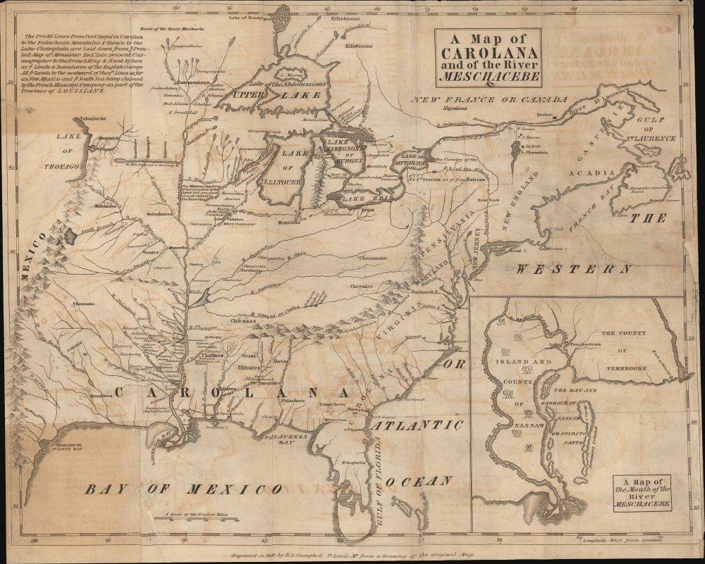
Illustrations, from above: Portrait of Sir Robert Heath, Lord Chief Justice by Cornelius Johnson; The Province of Carolina before and after the split into North and South Carolina (wikimedia); “Map of Coxe Patent, 1770” (Grand Division 1 is at far left near today’s Rome with the 1768 Stanwix Treaty Line as the straight line at the bottom, Grand Division 7 is at far right, Clinton village is in the green outlined area in Division 6 with Oriskany Creek serving as the boundary between the 5th and 6th Divisions; “Oneida County, Showing Patents, Grants &c. from Surveyor General’s Map, 1829; Detail of 1840 copy of Campbell map showing the Carolinas, the Mississippi and Iroquois Lands in New York from Coxe’s 1770 A Description of the English Province of Carolana (see a larger version here).
