
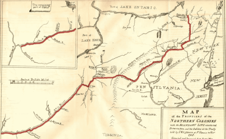
 Immediately following the American Revolutionary War (1775-1783), states in the newly created United States competed for control and settlement of Indigenous lands. This included much of Western New York, which was within Indian lands designated by the 1768 Treaty of Fort Stanwix, which set the boundary line between the colonies and native nations.
The Treaty of Paris of 1783 did not include the allied Native nations, leaving their legacy treaties with different European parties unresolved and their future to be determined through separate treaties with the new American government.
In September 1784 the Six Nations representatives began arriving at Fort Stanwix which was uninhabitable because it had burned down and was abandoned by the Continental Army in 1781. Temporary buildings were constructed, federal representatives arrived in October, and negotiations began.
The United States recognized the allegiance of the Oneida and Tuscarora nations during the Revolutionary War but admonished the Mohawk, Onondaga, Cayuga, and Seneca nations for their perceived support of the British.
As part of the treaty negotiations, the United States established the boundary for a reserve for the Six Nations that included much of today’s central-western New York State.
The reserve, which was the first example of a federally created American Indian reservation in the United States, did not include “six miles square round the fort of Oswego,” which was ceded to the United States for continued military activities.
 Federal representatives of the Native nations signed the Treaty of Fort Stanwix in October 1784, but Six Nations leaders later refused to ratify the treaty on the grounds the delegates lacked the authority to agree to the terms, including the enormous exchange of lands.
The US government ratified the treaty in 1785, but the Six Nations never did.
While the 1764 Treaty of Fort Stanwix recognized each of the Six Nations as sovereign nations and became a template for later treaties between the federal government and other American Indian nations, its promise to protect the Six Nations and the reserve’s land was not kept.
The day after the US government ratified the 1784 treaty, representatives from Pennsylvania negotiated a at Fort Stanwix with the Six Nations.
The northern and western boundary, established in Pennsylvania with the 1768 Fort Stanwix Boundary Line Treaty and subsequent clarifications, was pushed north and west to the state of Pennsylvania’s current northern and western borders (except the northwest triangle, added in 1792).
The entire Six Nations reserve was then within the boundaries of the state of New York. The United States negotiated other treaties with the Wyandot, Delaware, Chippewa, and Ottawa (January 1785); Cherokee (November 1785); Choctaw (January 1786); Chickasaw (January 1786); and Shawnee (January 1786).
These treaties contained articles and elements from the 1784 Treaty of Fort Stanwix and initiated waves of westward expansion by settlers and land speculators. Collectively, these treaties significantly diminished the influence, inter- and intra-nation stability, and land holdings of Native nations.
 In 1794, the Treaty of Canandaigua established the recognition of sovereignty between the United States and Haudenosaunee Nations and affirmed Haudenosaunee land rights, although it greatly reduced their land within central New York’s 1.75-million-acre “military tract” and restricted the Haudenosaunee Nations from making future land claims.
The treaty remains in effect and is memorialized in Canandaigua, NY, annually on November 11. In 2016, Haudenosaunee leaders met with US officials at the White House to commemorate and formally acknowledge the Treaty of Canandaigua.
Furthermore, the United States government maintains sovereign-nation-to-sovereign-nation relationships based on mutually recognized treaty rights with the federally recognized Haudenosaunee Nations.
Also in 1794, through the Treaty of Amity, Commerce, and Navigation between the United States and Great Britian — also known as John Jay’s Treaty — Great Britain agreed to withdraw all troops and garrisons within the US boundary created by the Treaty of Paris, including Fort Ontario in Oswego.
Read more about the Haudenosaunee.
This essay was drawn from the National Park Service’s 2024 Fort Ontario Special Resources Study, available in it’s entirety with footnotes here.
Illustrations, from above: Detail of 1840 copy of Campbell map showing the Carolinas, the Mississippi and Iroquois Lands in New York from Coxe’s 1770 “A Description of the English Province of Carolana”; “Map of the Frontiers of the Northern Colonies with the Boundary Line Established… at Fort Stanwix in November 1768” (NPS); and Diminished Iroquois lands after the American Revolution


Recent Comments