
 Albany’s proximity to the Hudson River made it an ideal trading center, beginning with Native American-Dutch fur trading in the early seventeenth century.
By the late eighteenth century, the city had cultivated a small lumber market consisting of a half-dozen wholesale lumber merchants, clustered just south of the neighborhood around Columbia Street and present-day Clinton Avenue (to the south of what would later be considered the “Albany lumber district” proper).
It was the completion of the Erie Canal in October 1825 however, that initiated a surge of commercial growth in the Capital Region, particularly the
establishment of the Albany Lumber District.
 Patroon Stephen van Rensselaer III (1764–1839) was a commissioner of the Erie Canal and served as the president of various other progressive boards and commissions. At the eastern terminus of the Erie Canal was Lock One and a small basin located at the south corner of Lawrence and Montgomery streets.
Identified in contemporary documents alternatively as the Basin, Canal Basin, the Erie Basin, and the Little Basin (the latter name is used here), this small waterway connected to the larger Albany Basin and the Hudson River.
Present-day Erie Boulevard follows the path of the Erie Canal, parallel to the Hudson River. Two private basins were constructed on the Van Rensselaer estate immediately north of the Little Basin.
These private basins and a large number of slips serving the lumber district were located between the Hudson River and Erie Canal.
 Improvements and expansions to the Little Basin and the canal were made as commercial traffic grew exponentially. Locks and a bridge that separated incoming from outgoing boats at the entrance to the Little Basin were constructed by 1856.
A weigh lock branched off the Little Basin and a weighmaster’s office was accessible by another bridge at Lawrence Street. These were torn down in the mid-1900s.
A series of bridges continued to be built to allow traffic to cross over the canal near the old city line, including one at North Ferry Street and at Bridge Street. A predominantly Irish immigrant neighborhood, also known as “The Basin,” grew around the Little Basin as industrial and residential construction boomed.
 Today, the Little Basin is buried under Colonie Street, Erie Boulevard and adjacent parcels. Due to the fact that much of the basin’s site has remained free from construction activities there is a strong likelihood that it remains largely intact; however, insufficient archaeological investigations have been undertaken to document it to date.
(An initiative is currently underway that hopes to reclaim the Little Basin and original Erie Canal Lock One for modern use.)
Between the river and canal, the executors of the Van Rensselaer estate established thirty-three parallel slips, which became collectively known as the Lumber District; this name appears on maps as early as the 1850s.
The estate’s contribution to the canal and excavation between the river and canal brought about the Albany Lumber District, bounded by North Ferry Street to the south and spanning approximately a mile from the Little Basin to the North Albany neighborhood.
Most of the leased lumber slips off the canal’s east side were excavated by 1857 and the rest existed by 1876. The area soon became the largest white pine market in the nation.
T he Erie and Champlain Canals pioneered fast transportation within the state and communication with the western United States and Canada, while the Hudson River provided ease in barging lumber to and from New York City and gave access to foreign markets.
With low handling costs and great speed, lumber was exclusively barged until the construction of the Hudson River Railroad.
The lumber trade brought immense wealth to several landowners and lumber firms in Albany, most notably the Van Rensselaer family, whose land made up nearly half of the Lumber District through the 1870s.
The 1876 City Atlas of Albany also shows the family manor house at the approximate location of present-day Manor Street. With little development spreading north or west of the lumber yards, the building could be seen from the canal.
The manor house was dismantled in 1893 due to the encroaching railroad and the Van Rensselaer family’s departure from the area, although they retained ownership of much of the land. The family’s leasing of their lands continued an arrangement that had been established with the creation of the manor in the seventeenth century.
 The 1870s saw the economic peak of the lumber industry in Albany. A map published in 1876 named thirty-five different companies occupying halves of each slip. In addition to the slips, the Lumber District consisted of open lumber lots and yards, wood-frame support buildings, and larger planing mills.
With the nationwide increase of industrialization and expansion of the rail system in the late nineteenth century, larger mills could now ship directly to building sites. Gradually the lumber district emptied; the slips were filled, and their sites became home to industrial buildings in the early twentieth century.
Notable local companies were the Callender & Mason, which dealt spruce, hemlock, and pine; G.H. Hunter & Son, which dealt in Florida Southern pine, used for floors and car sills; Blakeslee Lumber Company (approximately 981 Broadway); and Hubbell and Hill Lumber, later C. T. Hubbell (still operating ca. 1935-1951 with a warehouse at 7 Tivoli Street).
By the late 1880s, electric streetcars were introduced, and would dominate local public transportation for the rest of the century. Streetcars began to run from South Ferry Street to the Lumber District in June 1863 on Broadway and streetcar lines served the Lumber District into the twentieth century.
Between 1905 and 1918, the Erie Canal was replaced by the NYS Barge Canal system. The former Erie Canal and remaining laterals were abandoned in eastern New York State because of their inaccessibility to barges.
During the Barge Canal’s planning stages, it was found that the various railroad lines, often parallel to the Erie Canal, created problems with respect to corporate responsibility at their crossing points and ownership of the land between the canal and the railways.
The engineers of the Barge Canal solved this problem by deviating from the course of the former canal. The new canal shifted water traffic back through the Hudson River north past Troy, and northwest through the Mohawk River, utilizing natural waterways.
 For the Lumber District, this shift meant the abandonment of its foundational transportation corridor. Its fundamental role in Albany’s economic prosperity and industrial development was impacted and the area’s relevance shifted toward a reliance on the railroads.
Other industrial uses supplanted the Lumber District. For example, in 1917, a large factory for the Albany Perforated Wrapping Paper Company was built at 1271-1293 Broadway, covering some three acres of floor space.
(The company was founded by toilet paper innovator Seth Wheeler and originally located at a still-standing building at 150 Montgomery Street.)
A later plant, constructed as a paper mill for toilet paper and paper towels, was constructed in stages from 1918 to 1922 at 19 Erie Boulevard (it remains still standing) on the slips that had been connected to the Erie Canal.
The plant’s construction eradicated the last two lumber yards in the original Lumber District and into the 1930s the Lumber District slips were infilled and built over.
Holbrook Lumber, a major lumber distributor, is one of the last companies still in operation that traces its roots back to the Albany Lumber District. Founded in 1911, they later moved to Fuller Road in Colonie and eventually to the Northeast Industrial Park in Guilderland.
Rea more about New York’s Lumber Industry or read about the Construction Trades.
This essay is drawn from the Albany Industrial and Warehouse Historic District National Registration Form. You can find the full document, including footnotes, here. John Warren contributed to this essay.
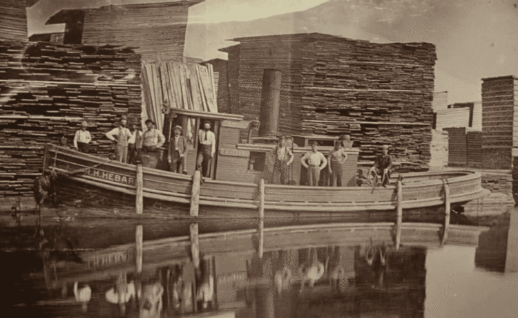
Illustrations, from above: The tugboat H.R. Hebard in the Albany Lumber District Yard, probably ca. 1875; 1832 Map showing the Erie Canal and Little Basin, before expansion in the mid-1830s; “The Entrance of the Erie Canal, from the Hudson River, at Albany, N.Y.” from Frank Leslie’s Illustrated Newspaper, 1856, showing the first lock, at the head of the Erie Canal (lumber can be seen stacked at either side of the entrance to the lock); Detail of E. Jacob’s map of the City of Albany (1857), showing the lumber district, Erie Canal and “Canal Basin” and the Van Rensselaer Manor house and grounds. Broadway (called “Troy Road” north of Tivoli Street, was largely undeveloped at that time (Albany Institute of History and Art); 1876 map showing some of the industrial development along Tivoli Avenue, the establishment of the North Albany neighborhood to the north of the Historic District, and the Erie Canal and Lumber District (G. M. Hopkins, City Atlas of Albany, NY, 1876); The southeast part of the Lumber District in 1876, showing the Little Basin at bottom center (G. M. Hopkins, City Atlas of Albany, NY, 1876); and the Frank A. Jagger lumber boat at Albany Lumber District, ca., 1875 featuring the immense lumber stored in the Lumber District (Albany Institute of History and Art).


Recent Comments