
 Tucked away between a car dealership and several corporate buildings at 25 Lafayette Street in Queensbury sits Hovey Pond Park, a serene oasis in the middle of suburban commercial development.
It’s a place for the jogger, the dog walker, the nature lover, and children seeking a playground. On a pleasant day, visitors may enjoy the park’s flower garden, fishing pond and wild life sanctuary, including a fast-running, bubbling creek that borders the park’s southern boundary.
Sitting prominently, yet unobtrusively, next to the pond’s walking path near a stream called Half-Way Brook is a granite stone with a patina-colored bronze plaque attached. The inscription on the tablet details the bloody history associated with the adjacent water, some two and a half centuries ago.
In 1904 the New York State Historical Association (NYSHA, now defunct but then charged with running Lake George Battlefield Park) selected Half-Way Brook as an appropriate site for a marker to commemorate the surrounding area’s 18th century history.
 A glacial boulder with its descriptive tablet was originally placed near the intersection of Upper Glen and Glenwood Streets in October 1905. The stone in Hovey Park is a replacement but the tablet is original.
The plaque reads:
HALF-WAY BROOK
So called because midway between Forts Edward and William Henry. From 1755 to 1780 it was the scene of many bloody skirmishes, surprises and ambushes. Here the French and Indians inflicted two horrible massacres upon the English and Colonials. One in the summer of 1756 and the other in July, 1758.
FORT AMHERST
A noted military post, was midway between this marker and the brickyard. Its site was known locally as “The Garrison Grounds.” The location was used as a fortified camp in 1757-58. The fort was erected in 1759. It was occupied by the forces of Baron Riedesel in the Burgoyne Campaign of 1777. It was burned in 1780 in the Carleton Raid at the time of the “Northern Invasion.”
THE SEVEN MILE POST
Was a block house with a stockaded enclosure which occupied the rise of ground north of the brook and west of the road, near the residence of W. H. Parker, from 1755 to Revolutionary times. During that period it was one of the most important halting places in North America.
— Erected 1905 By NEW YORK STATE HISTORICAL ASSOCIATION
 The stone caught my eye years ago when we were walking our dog in Hovey Pond Park. It usually goes unnoticed by park visitors. An internet search will tell you everything the park has to offer recreationally and environmentally; however, omitting its historical marker and why it’s next to the creek.
Half-Way Brook flows from the Luzerne Mountains (i.e. West Mountain) westerly until it turns north, emptying into Wood Creek at Fort Ann where it flows into Lake Champlain.
The famous French and Indian War ranger commander, Maj. Robert Rogers dubbed the stream “Bloody Brook” in his journal. A British engineering officer of the same era, Col. James Montresor called it “Half-Way Run” in his journal. An undated 18th century map identifies it as “Shone” Creek.
Later, during the Revolutionary War, Col. Henry Knox’s diary christened it “Seven Mile Creek” as he was hauling his “Noble Train of Artillery” from Fort Ticonderoga to the Siege of Boston in 1775.
These names were appropriate for two reasons. Half-Way Brook was basically equidistant between Fort Edward on the Hudson River and the end point of Sir William Johnson’s 14-mile 1755 military road at the southern shore of Lake George.
The fortified area was just south of Blind Rock, a boundary marker’s assumed by New France to be the edge of their territory.
Fort Amherst
After Johnson’s victory over the French at Lake George on September 1755, the midpoint between Fort Edward and Fort William Henry was identified by the British as a strategic location to build a fortification. Its purpose would be to act as a resting place for soldiers and teamsters as they traveled the road between the two forts.
A blockhouse was built within a stockaded enclosure covering about two acres, along with several store houses for munitions and supplies.
 According to a 19th century physician-turned-local historian A.W. Holden, the fortified depot “was situated on the north side of the brook and to the west of the plank road leading to the head of Lake George.”
Dr. Holden further claims that by 1759 the fortified stream crossing was protected by redoubts, rifle pits and earthworks; the entire encampment could accommodate about 800 men.
Fort Amherst, named in honor of the commander-in-chief of British forces in America, Jeffery Amherst, would be located on the south side of the creek.
[As a modern day reference, the blockhouse would have been near the Price Chopper parking lot entrance on Route 9 in Queensbury. A New York State historical marker also sits near Half-Way Brook on the east side of Route 9 north of the convenience store on the corner of Glenwood and Upper Glen Streets / Route 9.]
The French at Ticonderoga
In 1756 Great Britain still harbored thoughts of capturing Fort St. Frederic at Crown Point, plus the new French fortification (Fort Carillon) rising at Ticonderoga. With the completion of Fort William Henry as the British army’s forward base of operations, it was essential to supply this garrison with fresh meat and other foodstuffs.
Johnson’s military road from Fort Edward served this purpose. Long supply trains, of course, would be the target of French attacks several times during the campaigning season.
 The French army commander in Canada, Maj. Gen. Marquis de Montcalm sought to use these raids as a diversion to keep the British off balance. His strategic plans for 1756 focused on the capture of the English outpost at Fort Oswego on Lake Ontario. Fort William Henry would have to wait until 1757.
A Pennsylvania newspaper reported a letter received from Fort William Henry dated August 3, 1756 that described an attack on a supply train driving cattle and sheep from Fort Edward. It was hit “halfway” between the two posts by an enemy force of some two to three hundred.
Dr. Holden repeated this story despite some skepticism. However, he doubled the number to 600 Canadians and Indians and pinpointed the attack to Half-Way Brook.
According to Holden, “The oxen were slaughtered, the convoy [of teamsters and soldiers] mostly killed and scalped, the wagons plundered of their goods and stores.”
The marauding party retreated to South Bay on Lake Champlain to make their escape north. They were pursed by rangers under Robert Rogers and Israel Putnam with minor losses.
A French communique corroborates Holden’s story which is repeated on the NYSHA’s 1905 plaque. On July 21, 1756, the dispatch reported that “Chevalier Lacorne [Louis de La Corne] and M. Contrecoeur have taken their departure at the head of a flying camp of 500 Canadians and two hundred Indians, to observe the enemy’s movements whilst transporting their supplies from Orange [Albany] to Fort Lidius (sic) [Fort Edward] and that of Lac St. Sacrament, called [Lake] George.”
When British engineer Col. James Montresor was ordered to the New York colony in 1757, his keen eye spotted the immediate need to improve the works at Half-Way Brook. In July he told his journal that a post should be built on the south side of the “Run” on the east side of the road.
Montresor sent a carpenter to Half-Way Brook to start the work. Montcalm, however, interfered with the colonel’s plans by capturing Fort William Henry in August; so no work was done to improve the crossing at Half-Way Brook that year.
Half-Way Brook would play one more part in the bloody events of 1757. Following the surrender and “massacre” at Fort William Henry, Montcalm sent an emissary to Maj. Gen. Daniel Webb, pledging the safe escort of the remaining British prisoners, including Fort William Henry’s commander, Lt. Col. George Monro, to Fort Edward.
On a rainy Monday, August 15, about 500 English troops and civilians, accompanied by a French guard of 400 grenadiers and Canadian volunteers marched to Half-Way Brook. Webb sent two companies of his own grenadiers and 200 volunteers to meet the column.
Once the exchange was made, the POWs continued to Fort Edward with Monro mounted on horseback behind a 6-pounder leading the procession. The bronze gun was Montcalm’s gift to the stubborn defenders in recognition of their heroic efforts to hold their post.
Half-Way Brook would become even more prominent in the next two years of the war for empire in North America. A 1758 massacre there was every bit as lurid as the one described by James Fenimore Cooper’s pen at Fort William Henry, but it’s rarely mentioned today.
You can read about those events here in a 1905 historical sketch of Half-Way Brook by James Holden, prepared for the New York State Historical Association. Holden was the New York State Historian in the early 20th century.
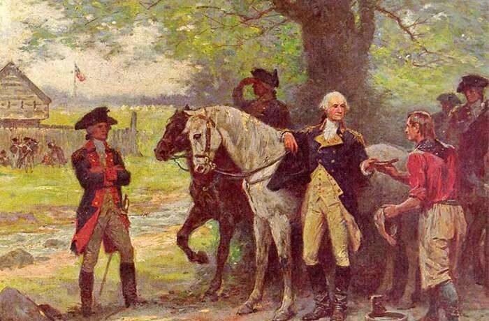
Illustrations, from above: Hovey Pond in Queensbury at Half-Way Brook and Fort Amherst (courtesy Queensbury Parks & Recreation); the original Half-Way Brook monument as it was installed in 1905; the rebuilt Half-Way Brook monument at Hovey Pond photographed by John Farrell, April 27, 2009; Jean Leon Gerome Ferris (1863-1930), “Washington at Halfway Brook,” 1895-1913 ” depicting “Fort Amherst” at the time of his 1783 trip to Northern New York, commissioned by the Glens Falls Insurance Company (Chapman Historical Museum); and French and Indian Wars Forts in Hudson Champlain and Lake George corridor (Warfare History Network).


Recent Comments