
 America’s first President George Washington owned 316 acres of land in today’s Town of Kirkland, Oneida County, NY, in partnership with New York State’s first Governor George Clinton.
The Oneida Indian Nation lived in what is now Oneida County, even after the area’s settlement by Europeans, which started in the 1600s. The French traveled through the area in the 1500s.
In October of 1615 Samuel de Champlain and Huron allies laid siege to a palisaded village believed by many to have been at Nichols Pond in what is now Fenner, just north of Cazenovia, Madison County.
(Historians and archaeologists continue to debate whether this specific site or an Onondaga village near Syracuse was the actual location of the battle.)
French, Dutch, and British kings claimed title to all these lands, even though they did not have the power to control them.
Until the 1770s English settlements had only reached the present-day Village of Herkimer, where Fort Dayton was built in 1776. The fort served as the staging ground for General Nicholas Herkimer’s militia before their march to the pivotal Battle of Oriskany in August 1777.
Oneida County had no permanent European settlements until 1773 with some in Deerfield (North Utica). Some Brotherton Indians had started to move to lands granted them by the Oneidas around 1774, but the Revolutionary War led most to return to Massachusetts (though some took shelter at Fort Stanwix).
The British crown claimed all land not already settled by Europeans and began to grant acreage to their friends, other nobility, and English colonial officials and Governors.
That was he case in 1770 when the loyalist Coxe family of Philadelphia received a 47,000 acre land patent which stretched from today’s Rome to Bridgewater along 22 miles of the Fort Stanwix Treaty Line of 1768.
This treaty boundary was approved by the Crown to protect indigenous lands to its west from European encroachment; it was an abject failure and settlement continually encroached westward. This attempt to restrict the taking of Indigenous lands was one of the contested issues during the American Revolution (1765–1789).
In October 1779, the State Legislature passed an act of attainder which allowed the state to seize loyalist lands. The Coxe Patent lands were divided amongst several family members with a mix of loyalist and patriot sympathies.
Some shares of the Coxe Patent were sold to Col. Marinus Willett, who was called “Savior of the Mohawk Valley” for his role in defending Fort Stanwix and containing loyalists and their Indigenous allies attacks in the valley between 1776 and 1781.
Willett bought and sold some 6,071 acres of the Coxe Patent to George Washington and George Clinton. These parcels were spread out in various parts of the patent and were located in the present-day towns of Westmoreland, Paris, New Hartford, Kirkland and Whitestown.
In November 25, 1782, George Washington sent a letter to George Clinton:
“I am sorry to have been disappointed in our expectation of the Mineral Springs at Saratoga and the purchase of that part of the Oriskany tract on which Fort Schuyler stands; but I am glad you have succeeded upon such advantageous terms in the purchase of 6,000 acres adjoining: for you have certainly obtained it amazingly cheap.”
[Fort Stanwix was then called Fort Schuyler, a name which had also been previously used for a short time for the fort at Utica. The “Mineral Spring” Washington references was High Rock Spring in what is now Saratoga Springs. The deal for the Saratoga lands ultimately fell through because the Livingston family had already claimed the property.]
According to George Washington’s will (written just before his death in 1799), they paid 1,062.5 pounds for the 6,000 acres, and by 1793 they had sold 4,000 acres of the parcels for a total of 3400.2 pounds in New York currency. At that time the lands were in Herkimer County as Oneida County was not formed until 1798.
The lands Washington and Clinton purchased included Lot 14 of the 5th division of Coxe’s Patent. This was 316 acres between the Oriskany Creek and the Westmoreland/Kirkland town line in the vicinity of Bristol Road (Route 233), Foote Road, Indianfield Road, Hilldale Drive and Saunders Road.
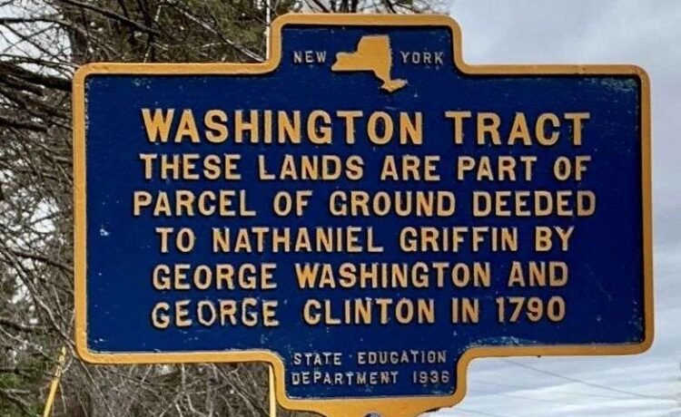
 In 1936 a state historic marker was installed at the corner of Foote Road and Route 233 calling that area the “Washington Tract” and stating that those lands were deeded by Washington and Clinton to Nathanial Griffin in 1790.
Griffin built the large Federalist style house just to the north of this marker in 1795.
Washington, one of America’s biggest land speculators, indicated his motives for the purchase in a letter to Chevalier De Castelluci on October 12, 1783.
French military officer and philosopher François-Jean de Beauvoir, Chevalier de Chastellux (1734-1788) served as a Major General in the American Revolutionary War.
The main liaison between Washington and the leader of French forces in the colonies Comte de Rochambeau, Chevalier de Chastellux published a firsthand account of the newly formed United States.
In his letter to Chevalier de Chastellux, Washington wrote:
“I have lately made a tour through the Lakes George & Champlain as far as Crown Point—then returning to Schenectady, I proceeded up the Mohawk river to Fort Schuyler [Fort Stanwix], crossed over to the Wood Creek which empties into the Oneida Lake, and affords the water communication with Ontario.
“I then traversed the Country to the head of the Eastern branch of the Susquehanna & viewed the Lake Otsego, & the Portage between that lake & the Mohawk river at Canajohario.
“Prompted by these actual observations I could not help taking a more extensive view of the vast inland navigation of the United States, from maps and the information of others; and could not but be struck with the extent and importance of it.”
Washington seems to have imagined the possibility of a canal across the state, perhaps encouraged by Philip Schuyler. In 1792 the Western Inland Lock and Navigation Company was created with Schuyler as president. Their goal was to create a continuous deep-water route between Schenectady and the Oneida Carry.
George Clinton’s nephew Dewitt Clinton led the effort to exploit the company’s improvements, finishing the Erie Canal in 1825.
Read more about Oneida County.
Illustrations, from above: Washington Tract historical marker (photo by Steve Stoessel, 2020); and Nathanial Griffin’s farm in Kirkland, NY, constructed in 1795.


Recent Comments