
 The following description is from 1941.
The Port of Albany is situated in the eastern part of New York State about six miles below the head of tidewater on the Hudson River and about 143 miles north of the Battery New York City. The port district as legally established embraces the city of Albany and the lands belonging to the city of Albany within the town of Bethlehem, the city of Rensselaer, and all lands and waters in the Hudson River contiguous thereto.
The district is an important rail center from which railroad lines radiate in all directions. It is only a short distance approximately six miles south of the eastern and southern termini of the Erie and Champlain branches of the New York State Barge Canal system.
The lower harbor comprises that portion of the Hudson River extending from the southerly end of Cabbage Island or Island Creek to a point about 1,000 feet south of the Albany Greenbush Bridge [the first Dunn Memorial Bridge, dedicated 1931] a distance of about three miles.
It contains the upper limits of the improved Federal channel 27 feet deep at mean low water and 300 feet wide along either side of which local authorities have dredged to a depth of about 30 feet at mean low water approximately to the full width 740 feet of the river.
The upper harbor comprises that portion of the Hudson River which extends from 1,000 feet below the Albany Greenbush Bridge to the northern limits of the cities of Albany and Rensselaer.
It contains the improved Federal channel 12 feet deep at lowest low water and 400 feet wide widened to about 600 feet to form a harbor at Albany.
Hudson River Depth and Tides
The Hudson River has its source in the Adirondack Mountains flows generally southward 315 miles and enters New York Bay at the Battery, New York City.
From New York City the controlling mean low water depth is 27 feet through a channel ranging in width from 180 to 400 feet to a point about 2,600 feet north of Van Wies Point [at what was known as the Lower Overslaugh, or Old Anchorage] and from 250 feet to 400 feet wide to a point about 2,850 feet south of the head of the 27 foot project [near the Upper Overslaugh].
Thence the channel is 17 feet deep at mean low water and from 300 to 100 feet wide to the head of the 27 foot project at the former Albany Greenbush bridge now the Dunn Memorial Bridge.
From this bridge to a point 200 feet south of the New York Central Railroad freight bridge [the Livingston Avenue Bridge] in Albany there is a channel 13 feet deep at lowest low water and from 200 to 400 feet wide; thence the channel is 11.5 deep for a width of from 270 to 520 feet to Bath Crossover Light; 11 feet deep for a width of 170 to 400 feet to the Delaware & Hudson Railroad bridge at Troy; and a width of 90 to 300 feet to the lock at Troy; thence it is 14 feet deep for a width of 200 feet to the head of the project at Waterford.
The channel is well marked by lights and buoys.
Although the Hudson River is influenced by tides as far north as the dam at Troy the river water is practically free from salt from Newburgh 60 miles above the Battery northward.
Many islands in the river north of Hudson and as far as Albany create a narrowing channel which has been protected in many places by training dikes built by the United States.
The tide ascends the Hudson River to the Federal dam at Troy NY. As at other points along the Atlantic coast there are generally two high waters and two low waters in 24 hours.
At Albany the average rise and fall is 4.6 feet. Extreme rise and fall affected by wind conditions and by variations in fresh water run off particularly freshets which occur in the spring and autumn and occasionally during other seasons vary from about 3.4 feet below mean low water to about 7 feet above mean high water.
The time interval from high water at the Battery New York City to high water at Albany is about 9 hours and for low water about 10 hours.
The tidal currents in the Hudson River are of moderate strength and do not adversely affect navigation At Albany the strength of the flood upstream current is about 0.3 knot and of the ebb down stream current about 0.8 knot.
During freshets [spring high waters] the upstream current is obliterated and the ebb or downstream current flows at varying velocities during the period of the tidal cycle The maximum strength during the freshets since the completion of extensive control works near the headwaters of the river [including Great Sacandaga Reservoir, created in 1930] seldom exceeds 3 1/2 knots.
The restricted width of the river at the port of Albany is not sufficient to permit vessels to swing at anchor without interfering with passing craft.
In an emergency vessels sometimes drop anchor in midstream to await berthing space but ordinarily berths can be secured without the necessity for vessels to lie at anchor for any extended period.
Vessels proceeding from New York to Albany often anchor overnight in the vicinity of Kingston about 53 miles below Albany to await daylight hours for passing through the narrower and improved channel from Hudson to Albany a distance of about 28 miles.
There are 14 bridge crossings over the Hudson River from its mouth at the Battery in New York City to Waterford. Of these nine are highway bridges four are railroad bridges and one is both a highway and railroad bridge.
Electric, Water, Coal and Oil Supply
Current for lighting and power is supplied in the Albany area by the New York Power & Light Corporation and is available in unlimited quantities. Alternating current 3 phase 60 cycles is supplied.
At the public wharves of the Albany Port District Commission lights are supplied at the rate of 25 cents per 100 kilowatt light per night or fraction thereof. Electric current for power for the operation of handling equipment for use on vessels is furnished at the prevailing rate not to exceed 8 cents per kilowatt hour.
The water supply of Albany is derived from streams in the Helderberg Mountains about 22 miles southwest of the city. The city of Rensselaer obtains its water supply from the Hudson River.
Fresh water is supplied to vessels at the port commission terminals between the hours of 8 am and 5 pm daily [in 1941] except Sundays and holidays at 60 cents per 100 cubic feet minimum charge $5. Additional charge is made for supply during other periods. Water supplied at private terminals is by private arrangement.
Coal for bunkers is available from local dealers and can be delivered to vessels by truck on the wharves or by barge alongside. A supply of coal is maintained by Martin S. Quinn for bunkering towboats which is handled by means of a car pit belt bucket elevator hopper and gravity chute on the Delaware & Hudson Railroad pier.
The Socony Vacuum Oil Co. Inc., the Atlantic Refining Co. Inc., the Shell Union Oil Co., and the Gulf Oil Corporation maintain a maximum supply of 460,952 barrels of bunker fuel oils
The Socony Vacuum Oil Co. is situated on the west side of the river at Albany in the section just north of the port district area. The bunkering capacity is 300 barrels per hour. The quantity on hand usually amounts to 70 percent of the maximum capacity of 320,000 barrels.
The Atlantic Refining Co. Inc. is located on the east side of the river at Rensselaer about 400 feet north of the turning basin and opposite the grain elevator on the Albany side of the river. Bunkering is only for the vessels of the company and can be performed at the rate of 238 barrels per hour. The supply on hand consists usually of 952 barrels of Diesel oil.
The Shell Union Oil Co. is situated on the east side of the river at Rensselaer about 1,500 feet north of the turning basin. The supply usually on hand is 80,000 barrels of Nos 2 and 4 fuel oil which can be bunkered at the rate of 120 barrels per hour.
The Gulf Oil Corporation which uses the facilities of the Shell Union Oil Co. maintains a supply of 60,000 barrels of Nos 2 and 4 fuel oil which can be bunkered at the rate of 120 barrels per hour.
This essay was excerpted from Port and Terminal Facilities at the Ports on the Upper Hudson River, 1941 (U.S. Government Printing Office, 1942) and annotated by John Warren.
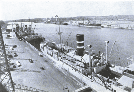
Photo: View of a crowded Port of Albany from the Lumber Terminal in ca. 1940-41.


Recent Comments