
 In the early 1700s the Mohawk Turnpike and the Seneca Turnpike were improved from the rougher Indigenous trails whose routes they utilized into regular, if rough, wagon roads. But it wasn’t until the 1790s that New York State’s turnpike era took off.
This was good news to migrants and local travelers alike, as deep ruts along the former “Indian trails” made transportation impractical and slow. It took days just to go a few miles and the limited number of ferries, bridges and fords often caused wagons to go miles out of their way to get around a lake, river, or creek.
It was considered too great a burden for the state to undertake road building at taxpayer expense and a popular opinion was that those who benefited should pay for the improvement. This left large road building projects to investors seeking revenues from tolls.
 The first Great Western Turnpike company, chartered by the State Legislature in 1799, organized the road of about 50 miles from Albany on the Hudson River, west to Cherry Valley south of Fort Plain, a community now in Otsego County, but having only recently been created from Canajoharie, Montgomery County).
The second Great Western Turnpike went from Cherry Valley to Sherburne, in Chenango County, through Cooperstown, starting in 1803 over a path close to Routes 80 and 166.
The Third Great Western Turnpike was chartered in 1803 to extend the road from Sherburne through Cazenovia (Madison County) to meet the Seneca Turnpike (Great Genesee Road) in Manilus, outside what is now Syracuse in Onondaga County.
Collectively this route was known as the Cherry Valley Turnpike, much of this route became Route 20. It travels west through the mostly rural area of farming hamlets and small villages south of the Mohawk Valley.
Cherry Valley
The village of Cherry Valley was settled in 1738 by John Kindsey. Some Scotch-Irish families from New Hampshire joined him to till the fertile soil along Cherry Valley Creek, a headwater tributary of the Susquehanna River.
 During the American Revolution, the village, then a base of forward operations for the Americans, suffered greatly on November 11, 1778 when a group of Loyalists, Mohawks, and Senecas attacked, many in retaliation for Patriot raids on Unadilla, Onaquaga, and Tioga.
A similar event had occurred in the Wyoming Valley of Pennsylvania that July. These precipitated the 1779 Sullivan – Clinton Expedition.
Cherry Valley was garrisoned by 300 men of the Continental Army’s 7th Massachusetts, commanded by Colonel Ichabod Alden. Alden had a palisaded fort built around the meeting house (Fort Alden).
About 15 Patriot combatants and another 30 inhabitants of the about 30 valley farms were killed. The attacking force had only five wounded – they captured an additional 30 Cherry Valley inhabitants and held them in various Iroquois villages until they were exchanged. Alden was killed and Lt. Col. William Stacy, the second in command, was taken captive to Old Fort Niagara.
The Third Great Western Turnpike Company
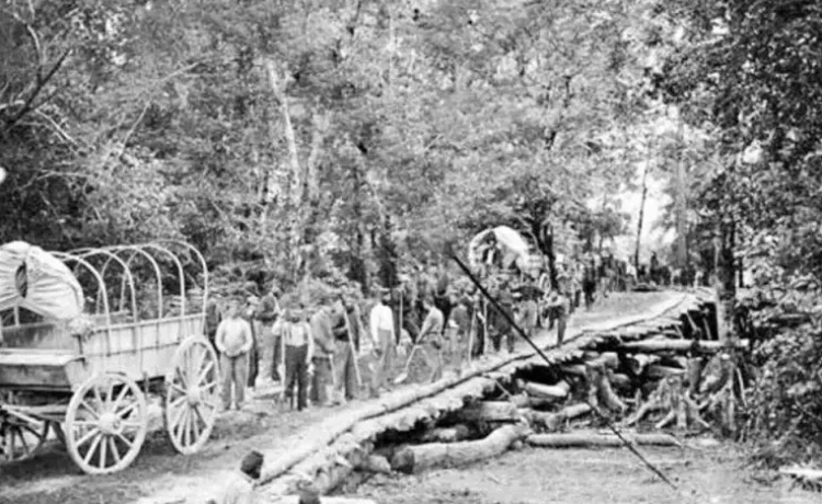
The Third Great Western Turnpike Company’s extension of the road from Sherburne to the Seneca Turnpike was about 70 miles long. This required large sums of money and manpower, and initially $100,000 was gained from sale of stock.
 By 1808 ten miles had been finished and tollgates would be every ten miles. Progress was made as a bridge was built over the Unadilla River in the Bridgewater area of Oneida County by Samuel Rindge for $500.00.
I appears that most of the road had been finished by 1810 as more toll gates were established at a meeting in the home of Uri Beach in Sangerfield that year. Wagons with tires six or more inches wide were exempt from any tolls as this kept the road packed down.
Financially profitable, the company paid a dividend as early as 1811 of $12.50 a share. One writer said that it was not uncommon to see hundreds of covered wagons in a single day pulled by powerful teams of horses.
This road connected Western New York’s lands that had not previously had easy access to bigger markets, which were mostly located on the Hudson River at the time.
Drovers, Inns & Stagecoaches
A stream of humanity, animals, and covered wagons traveled west on these turnpikes. Cattle, sheep, hogs, geese and other livestock were driven by “drovers,” as the animal tenders were called. Along the way “drovers’ stands” where established to serve the drovers, who bought local animals from farms and took them to market.
Teamsters hauled grains, beef and pork in barrels, and potash, and sleighs replaced the wagons in winter.
Traffic grew steadily until the War of 1812 put a halt to migrant travel. Troops in wagons loaded with arms and munitions headed west to Fort Niagara and Fort Ontario.
 After the war, more inns popped-up all along the road to provide lodging and food for the return of the numerous travelers and to rest horses. These inns and drover’s stands became stops on stage routes and small communities grew larger.
Stagecoach travel on the Cherry Valley Turnpike started in 1816 with a line carrying passengers and US Mail, the “Old Line Mail.” The trip from Albany to Auburn took two days. Other stage proprietors entered the market as demand to transport settlers and goods grew.
In 1816 the Cherry Valley Turnpike had paid dividends of seven percent, but the years of profits were numbered. The Erie Canal opened in 1825; lateral canals such as the Chenango Canal followed. The teamsters and drovers were hard hit by the canals, which assumed much of the long-distance heavy freight business.
The Utica & Schenectady Railroad reached Utica in 1835-36, and the turnpike died with the decline of the plank road era in the 1850s due to competition from railroads and canals.
The last toll on the Cherry Valley Turnpike was collected in 1857; by 1860, it was in disrepair. It became the property of New York State and part of it’s network of state roads.
Red more about New York State’s roads and turnpikes.
Illustrations, from above: Repairs on the Great Western Turnpike, 1880s; Cherry Valley, showing scenes from the Revolution (colorized), 1883; Map of NY Frontier in the Revolution (State Archives); Map of the Great Western Turnpike – Cherry Valley Turnpike route, by William McCalpin, 1808; Advertisement for a “New Line of Stages,” Albany to Manilus along the Great Western – Cherry Valley Turnpike, 1813.


Recent Comments